
THE PULSE, THE SINK, AND THE SHORTFALL
Brett Milligan + Tim Maly + Rob Holmes

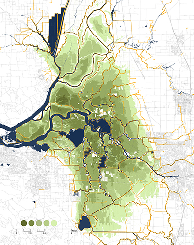
Operations, 2000-2013. Map by Brett Milligan
The Great Sediment Pulse began in 1852. These ere the dying days of the California Gold Rush. San Francisco—a settlement of about 200 residents in 1846—exploded to a population of about 36,000 by 1852. These settlers had come to look for gold or to profit off of those looking for gold. Mining was professionalizing and new engineering techniques were surfacing. Upstream in the Sacramento valley, there wasn’t much gold left for panning in the rivers, but there was still gold in the hills. Water was gathered in great basins, fed through pressurized hoses and directed at gold-bearing bluffs—a technique called hydraulic mining or hydraulicking. Entire hillsides of the Sierra Nevada range were washed into sluices and sieved for metal. By the mid 1880s, it is estimated that more than 340 million tons of gold were extracted in this way, bringing vital tax income for a country fighting and then recovering from a civil war.
The remaining debris washed into the rivers where it choked navigable channels, worsened floods and buried farmland. In 1882, a farmer near Marysville sued the largest mining operation in the region. In 1883, Edwards Woodruff v. North Bloomfield Mining and Gravel Company went to trial. In 1884, Judge Lorenzo Sawyer handed down a decision that ended hydraulic mining and led to the creation of the California Debris Commission in this landmark environmental case. But the pulse did not end.
Formation
Geologists and geomorphologists describe the San Francisco Bay-Delta as “well advanced,” referring less to the region’s urbane qualities and hi-tech industries, and more to the magnitude of human alteration and development of the estuary. It signifies our hydrological and earthen signature upon the place. The typical design pattern involves disruption—mining, deforestation, agriculture and urbanization—that increases the sediment load; followed by dams, water diversions and river management that reduce variability and sediment supply; and finally restoration of damaged habitat. The bay-delta, as a unique geographic feature, is radically different from what it was less than 200 years ago. How did we get to this?
The whole bay-delta system is relatively young, having been formed sometime between 6-10,000 years ago. San Francisco Bay is a drowned valley,5 carved out by rivers now below sea level. The delta sits 50 miles inland from the coast of California, confined by the Coast Range to the west and Sierra Nevada Mountains to the east. Where most deltas grow from a source river broadening towards the ocean, this delta broadens landward. By most standards it isn’t really a delta at all, just an accumulation of sediment at the headwaters of a very large estuary.
The delta was once something like a migratory inland sea, or a 12,000 square mile floodplain encompassing the entire Central Valley basin, including the Sacramento and San Joaquin Rivers. This porous landscape of tidal wetlands would expand and contract in tandem with California’s wildly fluctuating climate and precipitation. Inverted deltas, such as the bay’s, tend to fill in with sediment over time, creating a constantly shifting labyrinth of waterways. Mariners were known to get lost in this maze.

Delta Urbanization and Levee Failures.
The Ohlone people inhabited the Bay Area before the Spanish arrived. Their most prominent physical legacy is shellmounds—approximately 400 of them found around the perimeter of the bay. These accumulations of shells served as burial grounds, and potentially as protective high ground in the bay’s rich mud flats. In 1917, geologist Grove Karl Gilbert used Ohlone shellmounds to assess the fallout from hydraulicking. He measured their elevation in relation to tide lines to estimate the extent of subsidence or uplift. The biggest, Emeryville Shellmound, sat 60 feet tall and 350 feet in diameter. The mound was mostly leveled to make way for an industrial development and today it is the site of a shopping mall.
Disruption (1850-1915)
The Gold Rush and subsequent mining activity is the first pivotal anthro-sedimentary event in California. The liquefied hillsides were guided into wooden sluice boxes where gold, with the help of mercury, could be sieved out of the geologic slurry. In all, over 850 million cubic meters of sediment was flushed into the San Francisco Bay, approximately eight times both the amount of rock and dirt moved during the construction of the Panama Canal and the annual pre-pulse volume. The loosened debris ranged in size from silt and sand in suspension (called “slickens”), to gravel, cobbles and boulders. A contemporary geologist explained where it went: “Much of it
escaped from the mountains altogether and found eventual lodgment in the Great Valley of California or in the tidal waters of San Francisco Bay and its dependencies. The coarser stuff tarried by the way, building up alluvial deposits on the lower hill slopes, in the flatter creek valleys, and in the river canyons.”
Delta Subsidence. Data generated by 2008 Lidar from the CA Dept. of Water Resources.
This rapid erosion led to a flood in 1862, galvanizing riparian landholders: “The evils cited by them included the burial of alluvial farming lands by the flood of debris, the obstruction to navigation from shoaling of [the] Sacramento and Feather Rivers, and the raising of the flood levels of the valley streams whereby the area of periodic inundation was increased and protection against inundation became more difficult and expensive.”
Rivers such as the Yuba and Sacramento were silted in, vastly decreasing their capacity. Between 1849 and 1879, the Sacramento River bed was raised so much that low water levels rose nearly six feet. Though hydraulicking was banned in 1884, it did not end the pulse. Once the source of sediment was cut off, the disruption began to falter, but the effects persisted downstream. It takes indeterminate time for sediment, gravel and rocks to make their way through a river system, especially a broad shallow one like the bay-delta. In San Francisco Bay, the effects are measurable to this day.
Reclamation (1850-present)
At the same time that miners were washing hillsides out to sea, homesteaders were seeking to expand their holdings and to protect themselves—and their investments—from devastating floods. Left to its own devices, the delta would have seen regular flooding that would nourish soils and redraw channels. Homesteaders, however, wanted to protect their arable land from floods, especially those that buried the fields in mining debris when the waters receded. They also sought to deepen channels to maintain shipping corridors.
Beginning in the 1850s, farmers and towns began to build networks of channels and levees. They were first built by hand, largely using the labor of Chinese immigrants. Much like their counterparts upstream, the settlers soon began to mechanize. Though they experimented with dipper, hydraulic pipelines and bucket ladder dredges, it was the clamshell dredge that proved to be best suited to the task.
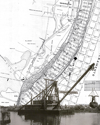
Clam Shell Dredger over Sacramento River, California Debris Commission Survey Map.
A clamshell dredge resembles a pair of monstrous jaws hanging off the end of a boom arm. When the jaws drop and hit the bottom, they snap shut. If the bottom consists of soft clay and sand, they grab a great deal of it, and the jaws are winched up to drain liquid away. The boom swivels easily, allowing the jaws to deposit the dewatered material precisely. Together, these features make the clamshell dredge particularly suited to cutting channels and building levees as part of the same operation. This versatile landscape machine could also be used to clear brush and trees and to roughen surfaces so that deposited dredge material would adhere better. From 1900 to 1915, the size of typical boom arms for delta-bay clamshell dredges extended from 100 feet up to 230 feet. People often describe the delta as a series of islands protected by levees, but that implies the dry land is above the water level, which it is not.
Surplus (1850-1950)
All told, the period from the mid 1800s to the mid 1900s saw a net sediment deposition. As the hydraulicking-driven pulse continued to make its way through the system, it joined a second, smaller pulse about 60% the size of the great pulse, likely driven by urbanization adjacent to the bay and the expansion of agricultural land use in the Sacramento and San Joaquin Valleys. As the pulse made its way through the delta and out to the ocean, it raised the entire profile of the bay, shifting the shoreline west, pushing back the Pacific Ocean and creating new beaches and marshlands.
Deficit (1950-present)
Starting around the 1950s, these trends reversed. Dams, riverbank protections and flood management all combined to produce net erosion in the bay-delta system. Dams starve the system by trapping sediment. As water slows upon entering a reservoir, it drops the sedimentary load into these anthropogenic deltas. Between 1950 and 1975, California’s reservoir capacity, already growing, had doubled. Combined with levees, the straitening of river courses and bank armoring, what sediment remained in the system was accelerated through the delta and into bay channels, where it would likely be dredged and lost to the watershed.
The Sacramento River once provided the most sediment for the bay-delta estuary. However, between 1957 and 2001 it lost half its supply due to dams and other infrastructure, thus contributing significantly to net erosion. Slowly, the landscape is washing away. Compounding that deficit, most of the anthropogenic pulse of sediment induced by hydraulic mining has passed through the bay-delta, leaving us with an unprecedented shortage of sediment in the watershed.
Choreographing Sedimentary Futures
The challenges and transformations experienced in the bay-delta demand new forms of geographic description and design research to explore how sediments and hydrological processes are choreographed at regional scales. “Every year, an average of three to six million cubic yards of sediments must be dredged to maintain safe navigation [channels] in and around San Francisco Bay.” This dredging allows massive container ships to continue plying ports. Oakland’s channels were recently deepened from 42 feet to 50 feet. San Francisco, Sacramento and Stockton channel deepening looms, as ship sizes and drafts continue to increase. Where these channels cut through the delta, salinity intrusion will follow, with cascading effects on already stressed aquatic habitats.
In the delta, the network of levees protecting subsided land has become more prone to failure: “Most levees were poorly constructed on weak, seismically unstable foundations. They are the [descendants] of originally small, private structures that have been expanded to cope with gradual land subsidence, sea level rise and erosion.” Economic analysis suggests that it is no longer cost effective to maintain all of these levees, and there is no practical way to do so. Wise triage must be performed, determining what earthworks will remain and what will transform into novel, open water ecologies. In light of these tremendous problems, how should we proceed?
In many regions, dredged material is now valued as a land-making resource rather than a waste product. In the bay-delta, the combination of sedimentary shortfalls, land subsidence and climate change make this particularly true, suggesting a future where dredged material levees, shorelines and wetlands all competing for access. Currently in San Francisco Bay, more than 50 percent of all dredged material is beneficially reused, and that percentage is even higher in the Delta. Intelligence and design foresight is accruing within the system. Where and how dredged material is moved around will in turn change the character of the complex processes of deposition and erosion that shape the landscape.
Dredgefest
To explore these questions, DredgeFest will arrive in the San Francisco Bay-D elta in 2016. DredgeFest is a roving event series, probing the distinctive features of anthropogenic geomorphologies on the four coasts of the continental United States since 2012. We take dredge as the starting point to examine the issues relevant to the design of riparian and littoral terrain, working at both regional and human scales of inquiry.
The location of each DredgeFest is also its topic. The series began on the Atlantic Coast, where the New York harbor struggles to define new uses for its massive sedimentary surpluses from port expansion to accommodate post-Panamax container ships.21 In Louisiana, it traced the contours of the continent’s largest river delta, the Mississippi, where the confinement of its geologic mobility by enormous infrastructures contributes to rapid land-loss and has prompted a crash program of experimental restoration sedimentology. Before arriving in California, DredgeFest will explore the Great Lakes basin, where shifting ecological, industrial and hydrological baselines require the recalibration of dredging practices and littoral landscapes.
Through components of symposia, design workshops, infrastructural tours and field research, each DredgeFest event works to reveal the role of sediment as a hidden infrastructure supporting contemporary urbanism. It probes the institutional, economic, cultural and social context of many diverse practices—including dredging—by which people speed up and slow down the movement of sediments, and offers strategies for investigating sedimentary futures. DredgeFest is a proactive experiment in transdisciplinary and participatory design, questioning the potential agency of design disciplines and examining what landscape architecture, as an integrative discipline, can bring to the table.
Brett Milligan is an assistant professor of landscape architecture at the University of California, Davis. His research focuses on land-water interfaces, seeking to meld ecological and infrastructural performance with aesthetics and expanded forms of public engagement.
Tim Maly is a writer and design journalist whose work focuses on the near future of design, architecture and infrastructure. He is a fellow at Harvard's metaLAB and a lecturer in industrial design at the Rhode Island School of Design.
Rob Holmes is an assistant professor of landscape architecture at the University of Florida. His research focuses on design responses to reciprocal relationships between urbanization, infrastructural networks and large-scale anthropogenic landscape change.
For more information on the 2016 event visit: http://dredgeresearchcollaborative.org/

Delta levees and historic channels.