
Making Ground/Farming Water
Tom Leader Studio
As awareness of climate change has grown, it has become increasingly clear that sea level rise will have a major impact on the future of urban coastal regions, including the San Francisco Bay Area. The bay’s water level rose seven inches between 1900 and 2000. Current projections for the next 100 years show a rise of four and a half feet. Sea levels are rising, and the rate is accelerating.
Design for Impending Change
Several design initiatives have begun to address the impact of climate change, such as the Museum of Modern Art’s Rising Currents exhibition (2010). This exhibition re-envisioned the area around the New York Harbor. The Hurricane Sandy Rebuilding Task Force and U.S. Department of Housing and Urban Development’s Rebuild by Design competition (2013) responded to Hurricane Sandy and the vulnerabilities it exposed. The San Francisco Bay Conservation and Development Commission’s competition Rising Tides (2009) addressed sea level rise in the San Francisco Bay.
For Rising Tides, Tom Leader Studio (TLS) submitted the design Making Ground/Farming Water. This proposal reshapes the topography of low-lying urban areas including Corte Madera Creek’s waterfront. The design proposes dredging deeper tidal channels and incrementally demolishing the many tilt-up concrete structures that will soon be inundated. The resulting rubble is then used to create a series of large island mounds, much like native Ohlone shellmounds. These islands could be accessible by a new urban fleet of boats, ferries and floating bridges. The island design anticipates growth and increased development including parks, neighborhoods, offices, farms and campuses. Other newly inundated zones could provide areas for saltwater farming of shellfish and biofuels.
Making Ground/Farming Water proposes a proactive strategy. It is one of the only entries that did not feature a levee. The design strategy demonstrates that sea level rise doesn’t have to be catastrophic. Many ecologically destructive things have been done around the edges of the bay, and sea level rise creates an opportunity to rebuild healthy wetland ecosystems. We must accept and adapt to rising tides, not back away from them.
Making Ground / Farming Water
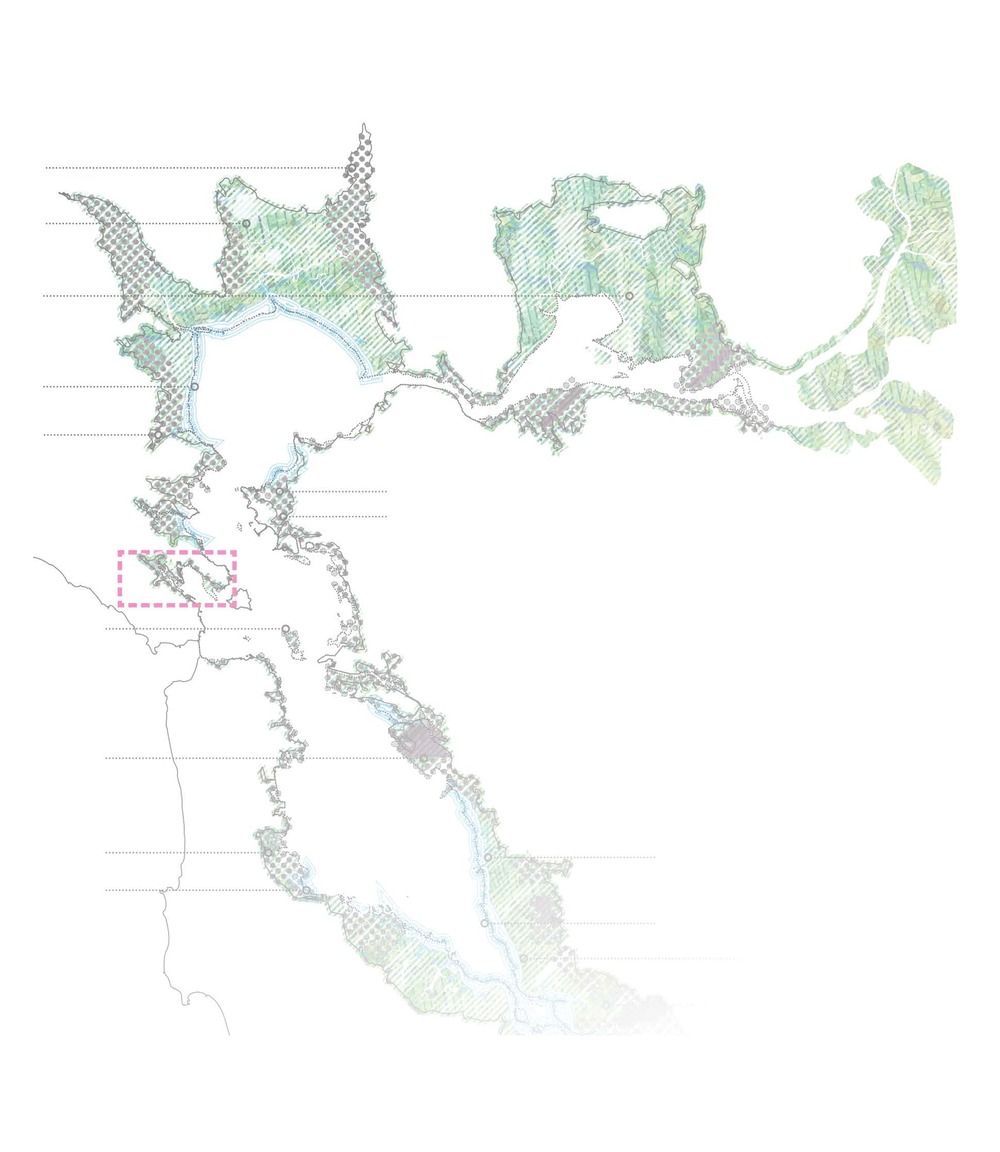
Until the arrival of Europeans in California, the fringes of San Francisco Bay were biologically rich, diverse and highly productive. The native Ohlone people lived well off the bounty of the vast salt marshes and shallow water habitats. Since then, this zone has been filled with society’s refuse and expedient items: landfills, highways, parking lots and tilt-up concrete structures. Rather than a problem, we view sea level rise as our second chance—a major opportunity to return these fringes to diversity and productivity once again. The historic technologies of Native Americans and medieval Venice provide successful precedents. Our proposal uses soon-to-be-inundated Greenbrae in Marin County to illustrate the possibilities of a future that is not reliant on levees.
Shellmounds 2.0
The Ohlone people built tremendous mounds along the bay using discarded shells, which provided dry, stable land to live and work within the mud and marshes. This design proposes a new archipelago of shoreline mounds inside the mouth of Corte Madera creek as it meets the bay. These will be anchored by layers of roadway and building rubble from structures that will soon be underwater. They will be overlaid with dredged material from the creation of a new network of tidal and navigation channels threaded through the archipelago and linked to upland streams.
The mounds provide new areas for re-development of the existing Corte Madera shopping center, single- and multi-family housing, new research campuses, energy production and parks. They connect to the mainland through bridges and a fine-grained aquatic transportation system of water buses, family-size boats and kayaks. These are all linked to an ‘interboatal’ hub at the Larkspur Ferry Terminal. San Quentin becomes a destination hotel and regional aquatic center with submerged warehousing converted to a mound-based wind farm and wind-surfing village.
Construction
Liquefaction in this location is the biggest construction issue. Brittle, monolithic structures are the underlying problem. A newer, more flexible system is needed. One useful precedent is the ancient Venetian system of wood pilings driven into consolidated mud and rubble to support flexible wood and aluminum frameworks, as it allows seismic movement. Low-lying Highway 101 can span between mounds by floating bridges similar to the Mercer Island Bridge in Seattle. Cars can be concentrated on a ‘cloverleaf mound’ with parking structures and links to other modes of transportation.
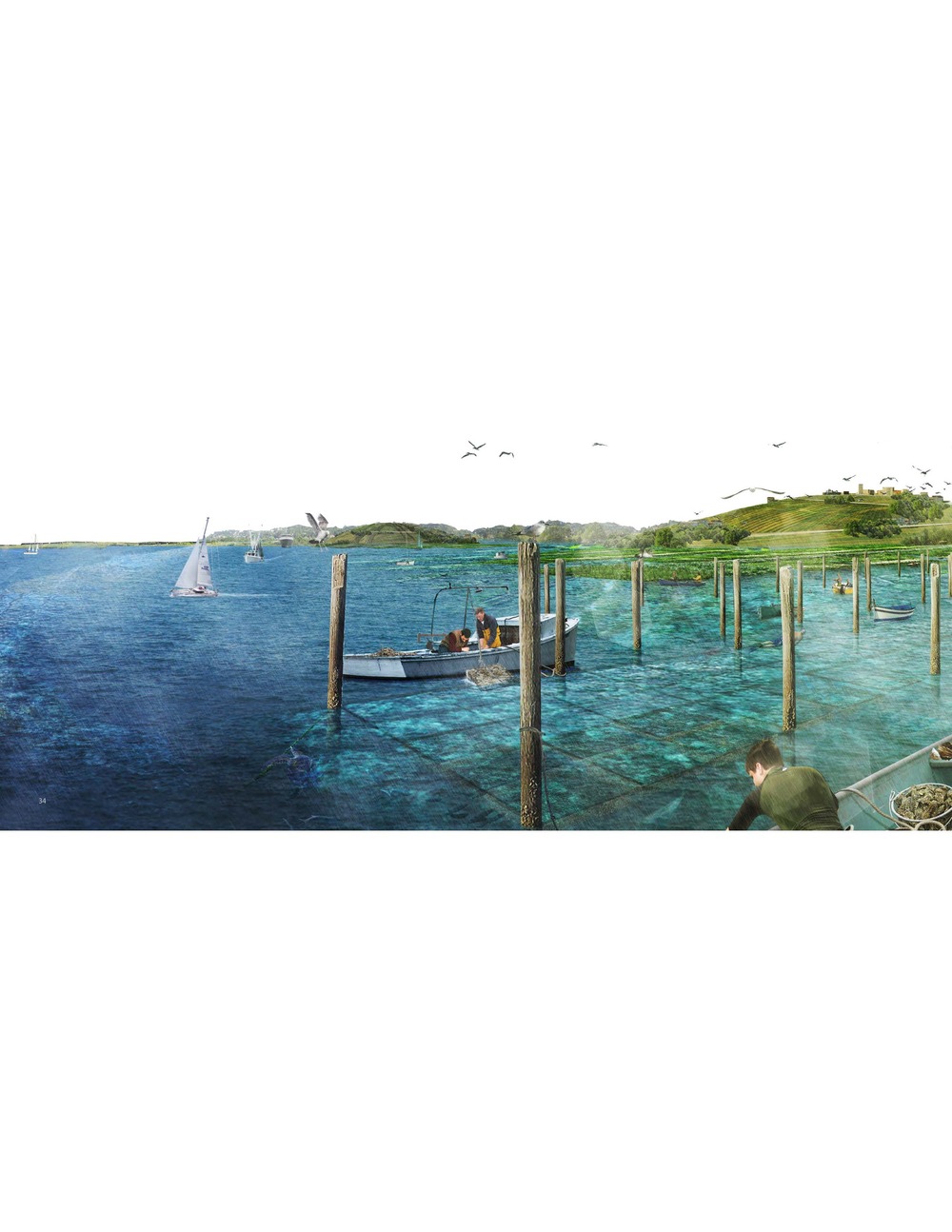
Scaffold reefs allow for cultivation of shellfish. crab and salmon.
Saltwater Chinampas
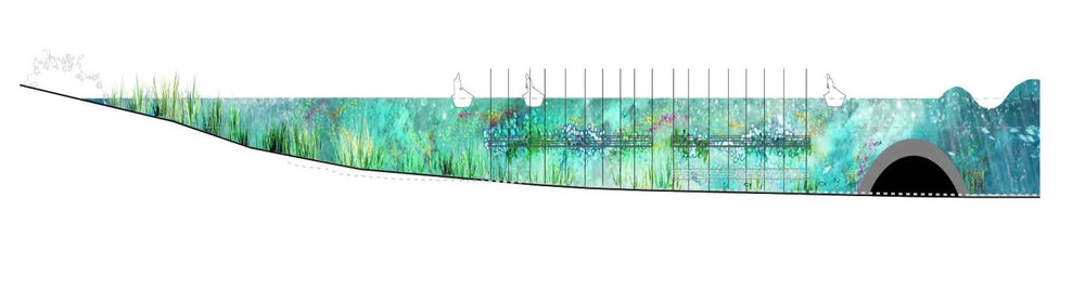
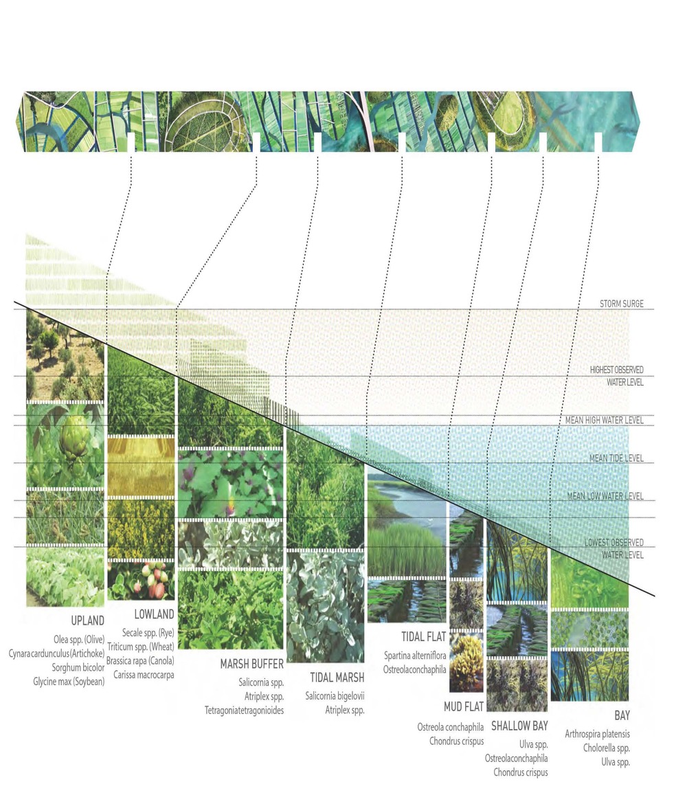
The design borrows from the Meso-American tradition of fencing an area in shallow water and filling it with organic dredge material. This technique allows areas between mounds and tidal channels to be intensively cultivated. Saltwater agriculture will be a crucial new source of global food production as sea levels rise. Salt-tolerant (halophytic) species yield unusually high levels of bio-mass for both food and ethanol production, as well as efficient remediation of metals and chemicals in tidal water. The tidal zones will also provide massive new areas for sustainable fish and shrimp farming, using the harvested fish waste as crop fertilizer. Shellfish habitats are created in deeper areas closer to wave action, where parallel artificial reefs are built using building rubble. The spaces between reefs are sheltered for salt marsh and eelgrass remediation.
Tidal Production
The zone of tidal fluctuation is naturally diverse with species filling every ecological niche. The design cultivates both native marshes and emergent wetlands, with adapted agricultural food and textile crops. As people once worked to eliminate these zones of ambiguity, we can now radically expand them to produce both ecological function and human sustenance.
Scaffold Reefs
An artificial reef made of concrete rubble is constructed initially to diffuse incoming waves. Then a framework of recycled sewer and plumbing pipes, filled out with re-used electrical conduits, is driven into the mud or supported by pontoons and anchored. This framework can be extended as tidal zones move upland and can be reoccupied as a farmable surface as sedimentation occurs.
The productive landscape also extends into sub-tidal zones. Oysters, a keystone species in the San Francisco Bay, once grew in abundance along its shores and were harvested by native people of the area. The Ohlone consumed oysters in such large quantities that shellmounds reached up to 60 feet high. Oysters act as a natural filter, clearing nitrogen compounds from the water and maintaining healthy water quality. The aggregation of oyster shells also creates habitat for an array of other tiny organisms, increasing the surface area of the benthic zone up to fifty-fold. Shellfish, crabs and salmon can be cultivated in a flexible pole-mounted system. Within these extensive ‘scaffold reefs,’ a variety of tanks and netting schemes can be lodged to accommodate the needs of different species. Waste from tanks can be harvested to fertilize the chinampas. Once salmon fingerlings are big enough for nets, they are exposed to daily tidal flushing to reduce waste concentrations in the water. With skilled management, salmon can be produced at a volume close to that seen in pre-Colonial times.
Investigating Further
Making Ground / Farming Water is an interesting story, but also a drastic response to an incremental problem. It would require something major to set it in motion, which led us to consider the Bay Area’s other major environmental concern: seismic activity.
It is generally assumed that the region is due for another major earthquake in the next ten to twenty years. When this happens, liquefaction will generate large quantities of rubble. What will cities do with all this material when the next ‘big one’ strikes? The next iteration of our proposal plans for both sea level rise and seismic activity concurrently, using catastrophic change as an opportunity to create something
positive.
What if we could use the necessity for rebuilding as an opportunity to reshape our topography—simultaneously adapting to sea level rise, repurposing rubble as construction material and creating strategic landforms in zones vulnerable to liquefaction? What if, by addressing sea level rise and seismic activity as two connected issues, we could better situate ourselves to go beyond disaster planning to create something positive in the long run? We have begun to investigate the feasibility of this idea by examining the intersection of sea level rise and seismic activity from a scientific and planning perspective.
The benefit of staying firmly grounded in scientific reality is learning what is feasible and what is not. Relying on an unpredictable future event to solve a gradual, predictable problem is not the best solution. We need to proactively plan for both, rather than depend on one to set the other in motion.
Our research has led us into other regional problems like socioeconomic disparity—namely vulnerability and resilience in the face of natural disasters. Who is our design helping? Disaster planning cannot be thought of solely in design terms. We have shifted our focus from the previous site in affluent Corte Madera to nearby Richmond, a city that has faced major economic struggles. We began to question how to use our previous design concepts—floodable wetlands and landfill islands—to bolster Richmond’s resiliency and revitalize its economy. We are investigating how Richmond’s 35 miles of waterfront can be put to better use. We are currently addressing these questions with our interns in the Richmond Shoreline
Studio Project.
Although we are addressing daunting problems—incremental flooding of large areas of the Bay’s urban edges and destabilization of those same areas—there is still time for critical thought and long range planning. The San Francisco Bay was full of abundance and biodiversity only 150 years ago, and today we have the chance to regain a dynamic relationship with the bay waters.
Tom Leader is the Principal and founder of Tom Leader Studio, an award-winning landscape architecture firm in Berkeley, CA. With interest and experience in large scale work, Tom nevertheless seeks what is personal and original in pursuit of the pragmatic in acclaimed projects such as Railroad Park in Birmingham, AL, RiverFIRST in Minneapolis, MN, and numerous site works and art installations. Tom received a BA from UC Berkeley and MLA from the Harvard University Graduate School of Design.
Emily Leader is the Marketing & Administration Coordinator at Tom Leader Studio. She holds a BA in Art History from Hampshire College.